26/7/14 A drive to the light industrial estate just over the large Taw Bridge enabled us to walk straight on to the Tarka Trail/SWCP. The going was flat and straight alongside the river and we soon arrived at Braunton Inn.
Some staff were arranging the garden furniture, so we asked if they we're open. Not until 11:30 came the reply. So we carried on. The old railway line heads inland past the Chivenor military bases until eventually reaching Braunton. Before actually getting into the town, we were diverted off towards the burrows.
The tide was out on the river Caen and, much like the burrows on the other side of the Taw, this area makes for interesting walking. There is an interesting cross-section of wildlife too.
The path goes along the flood defences for a few miles until reaching the sand dunes. We were expecting things to get a bit sandy, but the path follows an old, stony, military track instead. It was a hot day. I was expecting us to have seen a shop by now. Luckily, one of the car parks' attendants was selling bottled water. After crossing the golf course, we were given an option of walking along a busy road or heading inland "avoiding local amenities". We naturally went to see if the amenities included a pub. A soft drink and chocolate bar later, we climbed our first hill of the day.
After another walk along the road, we arrived in Croyde. The beach was busy and we must been quite conspicuous amongst the scantily clad holiday makers. On leaving the beach we could have waited for a bus back to the car. But, we had made good time and decided to go on around Baggy Point.
Coming out above the beach at Putsborough, we decide to head back along the road to Croyde. A refreshing cider and nice pasty later, we caught the bus back to the car. Then we returned to the surprisingly pleasant Braunton Inn for pints of Otter Ale (4.5%) and Tribute (4.2%) for £6.70.
Bideford to Barnstaple
22/7/14 Busy weekends meant that we had to do another midweek trip. My daughter kindly dropped us at South Molton where we could get a £3.60 North Devon bus ticket for the day. Before we started the walk, we had to return to Appledore.
The Royal George was shut on our last visit. I'm fairly sure that we were the first visitors on this day. It took us about ten minutes to get served and then the only ale went off. So it was pints of Liquid Sunshine (3.9%) and Poundhouse cider (6%) for £7.20 before the bus back to Bideford.
The Kings Arms appeared to be the only pub still trading along Bideford's Quay. We had two nice pints of Atlantic (4.2%) and Devon Dympsy (4%) for a reasonable £5.80. This was easily the best beer of the whole day. Then it was over the Torridge to the old railway station and off along the Tarka Trail. This is the old railway line, now tarmacked over and shared with cyclists. We headed back down the estuary.
We passed Appledore Shipyard and after we came through Instow Station, turned off the track and headed along the front.
The Bar had been advertising itself along the path as a quayside pub, so we felt obliged to go in. Pints of Doom Bar (4%) and Atlantic (4.2%) for £6.90 were quaffed, but we were still undecided whether it is a bar/restuarant or a pub.
The Instow Arms is just a few hundred yards further on. We had pints of Silver Stallion (4.3%) and Clearwater's Honey Beer (3.7%) for £7.20 in what also felt like an eatery.
Soon we were walking along the road beside the nice looking beach at Instow. This gave way to some dunes before the path skirted around the splendid cricket ground. We then followed the river before returning to the Tarka Trail. The next few miles are flat, straight and relatively boring. On reaching the outskirts of Barnstaple, the usual big town confusion meant that we followed the acorn sign over the new bridge. Once across the river, the signs pointed in both directions along the Taw. We followed them back to the town centre and the bus to South Molton.
The Royal George was shut on our last visit. I'm fairly sure that we were the first visitors on this day. It took us about ten minutes to get served and then the only ale went off. So it was pints of Liquid Sunshine (3.9%) and Poundhouse cider (6%) for £7.20 before the bus back to Bideford.
The Kings Arms appeared to be the only pub still trading along Bideford's Quay. We had two nice pints of Atlantic (4.2%) and Devon Dympsy (4%) for a reasonable £5.80. This was easily the best beer of the whole day. Then it was over the Torridge to the old railway station and off along the Tarka Trail. This is the old railway line, now tarmacked over and shared with cyclists. We headed back down the estuary.
We passed Appledore Shipyard and after we came through Instow Station, turned off the track and headed along the front.
The Bar had been advertising itself along the path as a quayside pub, so we felt obliged to go in. Pints of Doom Bar (4%) and Atlantic (4.2%) for £6.90 were quaffed, but we were still undecided whether it is a bar/restuarant or a pub.
The Instow Arms is just a few hundred yards further on. We had pints of Silver Stallion (4.3%) and Clearwater's Honey Beer (3.7%) for £7.20 in what also felt like an eatery.
Soon we were walking along the road beside the nice looking beach at Instow. This gave way to some dunes before the path skirted around the splendid cricket ground. We then followed the river before returning to the Tarka Trail. The next few miles are flat, straight and relatively boring. On reaching the outskirts of Barnstaple, the usual big town confusion meant that we followed the acorn sign over the new bridge. Once across the river, the signs pointed in both directions along the Taw. We followed them back to the town centre and the bus to South Molton.
Bucks Woods to Bideford
24/6/14 No free weekends, so we thought that we should do a midweek walk while the weather was good. Drove to Bideford for the first bus to Bucks Cross. It was £1 for an all-day park and £1.50 on the bus. Through the holiday park to the path where we continued through the woods. A mile or so later we came out into Bucks Mill, a quiet little place.
It was soon back into the woods. More than the first hour of this walk was in the woods and would have been twice as long had we started at Clovelly. With only the occasional glimpse of the outside world, it started to get a little claustrophobic.
After Peppercombe, it started to open out. Unusually, we found ourselves on a deserted beach for a short stretch only to be greeted by man-made debris.
They were a few rolling hills then to take us on towards Westward Ho. We managed to lose the path there, but eventually came back out on the promenade.
It was soon back into the woods. More than the first hour of this walk was in the woods and would have been twice as long had we started at Clovelly. With only the occasional glimpse of the outside world, it started to get a little claustrophobic.
After Peppercombe, it started to open out. Unusually, we found ourselves on a deserted beach for a short stretch only to be greeted by man-made debris.
They were a few rolling hills then to take us on towards Westward Ho. We managed to lose the path there, but eventually came back out on the promenade.
The Surf on Inn looked a bit garish, but was pleasant enough for two pints of Tribute (4.2%) at £6.90. Then it was on to Northam Burrows. This was an interesting, unsegregated area of beach car park, golf course, sheep and horse grazing and low-lying sand dunes.
After rounding that, Appledore came into view. The Royal George was shut and so the Beaver Inn was our first stop.
Pints of Otter Ale (4.5%) and Tribute (4.2%) for £6.70 with a game of pool here. Further along the quaint narrow streets, we came to the Seagate Inn on the quay.
We had pints of Smiler (3.7%) and Tribute (4.2%) for £6.70 in this 'poshified' establishment. The path then skirts inland around the shipyard, before continuing up the river, under the A39 bridge and into Bideford.
Hartland Quay to Bucks Woods
14/6/14 Another sunny day and we drove to Bideford Bay Holiday Park. The car park next to the shop looked to be close to the path and so we parked there and walked back to the main road for the bus to Hartland. A pasty later, we were walking along the shady road back to the quay. We'd already done the hill up to the toll booth and so we started along the cliff top.
St Nectans had been visible for the last few miles of the previous walk and was still there for the start of this one. The open countryside and cliff tops continued with the ups and downs as we headed towards Hartland Point.
There is no access to the Point and lighthouse itself and the area is a jumble of ancient and modern Coastguard and MoD structures. There is a refreshments cabin in the car park though which we made use of as it is the only one on this leg.
As soon as you round the point the character of the path changes for the first time in days and you find yourself walking through undergrowth and cultivated fields. There are still some ups and downs though as you approach Blackchurch Rock.
After that you find yourself on tracks in woodland heading towards Clovelly. It seems strange that the coastpath doesn't go through Clovelly itself, it just skirts around the hills above with glimpses of it through the trees.
There are possible routes through it which would surely benefit SWCP and the village owners. We did decide to deviate to the New Inn at the top of the village for some local ale. The path continues along a wide track for a few miles before emerging out into some fields. Soon an unsigned path branched off to the right and within a couple of hundred yards, we were back at the car.
St Nectans had been visible for the last few miles of the previous walk and was still there for the start of this one. The open countryside and cliff tops continued with the ups and downs as we headed towards Hartland Point.
There is no access to the Point and lighthouse itself and the area is a jumble of ancient and modern Coastguard and MoD structures. There is a refreshments cabin in the car park though which we made use of as it is the only one on this leg.
As soon as you round the point the character of the path changes for the first time in days and you find yourself walking through undergrowth and cultivated fields. There are still some ups and downs though as you approach Blackchurch Rock.
After that you find yourself on tracks in woodland heading towards Clovelly. It seems strange that the coastpath doesn't go through Clovelly itself, it just skirts around the hills above with glimpses of it through the trees.
There are possible routes through it which would surely benefit SWCP and the village owners. We did decide to deviate to the New Inn at the top of the village for some local ale. The path continues along a wide track for a few miles before emerging out into some fields. Soon an unsigned path branched off to the right and within a couple of hundred yards, we were back at the car.
Bude to Hartland Quay
31/5/14 I'm afraid that I forgot my camera for this trip. We parked in St Nectans car park in Stoke and then walked back to Hartland for the bus to Bude. After the previous week's exertions, I decided to bring a rucksack this time. I found a site saying that we had ascended over 5000 feet on that trip. A mere 4500 to go this time.
The walk out of Bude is easy enough, even if the lack of signs continued.
But it wasn't long before the ups and downs started. They kept coming.
I was waiting for the Devon border to appear and when we came across the Devon Wildlife Trust site at Marsland, I thought that we were there. But no. Fortunately we soon were though and Sid replenished himself with water from a hut.
There were various animals grazing the cliffs from here.
Embury Beacon marked the high point and we were lucky that the walk after that was mainly a gradual downhill one to Speke's Mill.
The signs there were confusing again, but we soon stumbled into the Wreckers Retreat at Hartland Quay.
Pints of Hartland Quay Bitter and Healey's Cider for £6.80 didn't touch the sides before walking up the hill and back to Stoke.
The walk out of Bude is easy enough, even if the lack of signs continued.
But it wasn't long before the ups and downs started. They kept coming.
I was waiting for the Devon border to appear and when we came across the Devon Wildlife Trust site at Marsland, I thought that we were there. But no. Fortunately we soon were though and Sid replenished himself with water from a hut.
There were various animals grazing the cliffs from here.
Embury Beacon marked the high point and we were lucky that the walk after that was mainly a gradual downhill one to Speke's Mill.
The signs there were confusing again, but we soon stumbled into the Wreckers Retreat at Hartland Quay.
Pints of Hartland Quay Bitter and Healey's Cider for £6.80 didn't touch the sides before walking up the hill and back to Stoke.
Boscastle to Bude
24/5/14 Three weeks since our previous walk, so we decided to risk the showery forecast. It was an early start for the drive to Bude. The A30 was busy as you'd expect for the school holidays, but the A road to Bude wasn't. We arrived in time to find a street parking spot and were at the bus stop for the first bus of the day to Boscastle.
Some sausage rolls later, we were on our first ascent. Pentargon with its waterfall was the first bay.
The shale rock looked even darker in the overcast conditions. It wasn't raining, but the ground was wet. Soon we came across the imaginatively named Gull Rock.
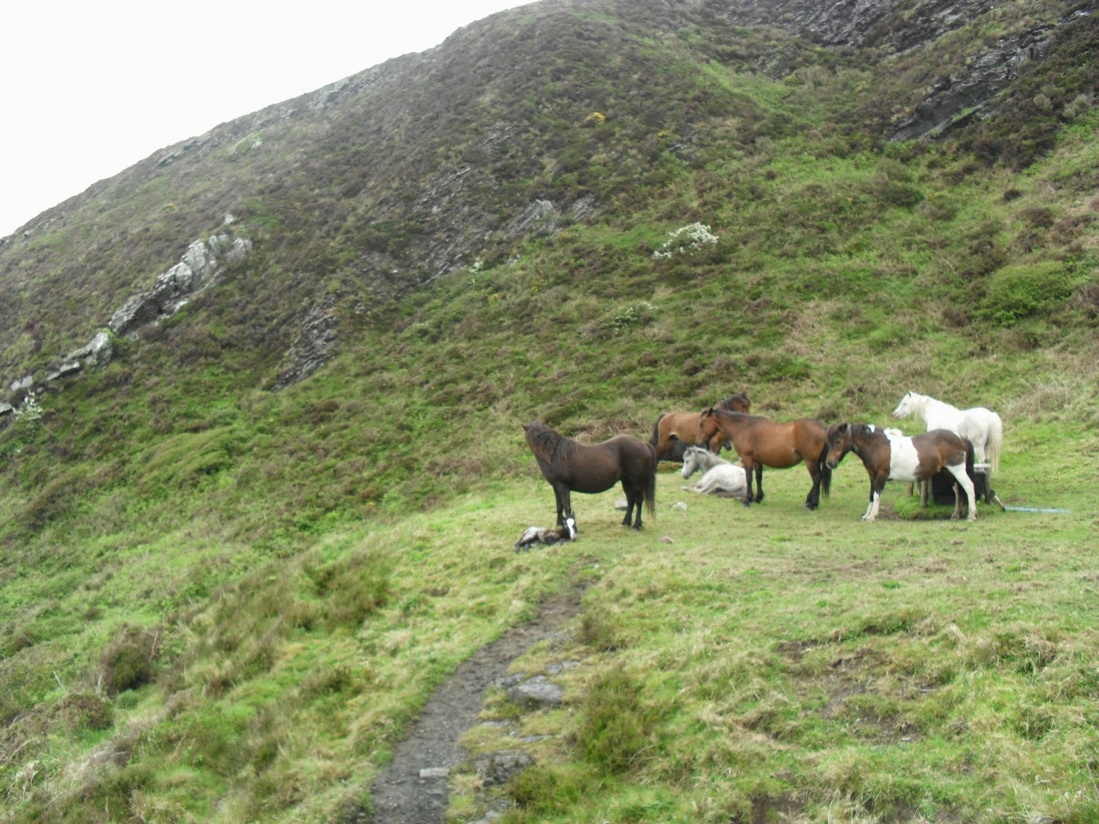
On the descent to Rusey, we came across a new born foal.
At the bottom of hill, we chatted to someone whose other half had gone back to check the health of the new born. The next big hill led to another clever place name, High Cliff.
Quite a tough climb, this one. The hills kept coming and shortly after we came across some of the locals enjoying a rest.
The geology at Cambeak looks interesting, but signage is confusing.
After a lap of the headland, we headed down to Crackington Haven.
The Coombe Barton Inn is the large white building near the front. We had pints of Tribute (4.2%) and Arthur's Ale (4.4%) for £6.40 and a couple games of pool. On leaving the pub, we met the party that were looking at the ponies earlier. "Brutal" was how he described the next section. Walking past the pub on the road, we found path signs again and ascended on past the above photograph point. The ups and downs kept coming.
Above is the slightly unnerving descent towards Stoneivy Rock. The climb out towards Dizzard Point nearly finished me off.
It does get gradually easier from here on, but had there been a bus stop in Millook, I wouldn't have completed this section on that day. At Black Rock, the cafe was just about to close as we dragged ourselves in. A pint of cider and some chocolate later, we decided to press on. It started to rain for the first time and, at last, we were glad that we had carried our coats up those hills. We rounded Compass Point and descended into Bude feeling a lot better than we had an hour before. The lack of coastpath signs in the town made us wonder about the correct route, but I think that is a way for the town get you to wander into their shops etc. We returned to the car. It took me another ten minutes to get in though, as cramp was my body's way of telling me how "brutal" it had been.
Some sausage rolls later, we were on our first ascent. Pentargon with its waterfall was the first bay.
The shale rock looked even darker in the overcast conditions. It wasn't raining, but the ground was wet. Soon we came across the imaginatively named Gull Rock.
On the descent to Rusey, we came across a new born foal.
At the bottom of hill, we chatted to someone whose other half had gone back to check the health of the new born. The next big hill led to another clever place name, High Cliff.
Quite a tough climb, this one. The hills kept coming and shortly after we came across some of the locals enjoying a rest.
The geology at Cambeak looks interesting, but signage is confusing.
After a lap of the headland, we headed down to Crackington Haven.
The Coombe Barton Inn is the large white building near the front. We had pints of Tribute (4.2%) and Arthur's Ale (4.4%) for £6.40 and a couple games of pool. On leaving the pub, we met the party that were looking at the ponies earlier. "Brutal" was how he described the next section. Walking past the pub on the road, we found path signs again and ascended on past the above photograph point. The ups and downs kept coming.
Above is the slightly unnerving descent towards Stoneivy Rock. The climb out towards Dizzard Point nearly finished me off.
It does get gradually easier from here on, but had there been a bus stop in Millook, I wouldn't have completed this section on that day. At Black Rock, the cafe was just about to close as we dragged ourselves in. A pint of cider and some chocolate later, we decided to press on. It started to rain for the first time and, at last, we were glad that we had carried our coats up those hills. We rounded Compass Point and descended into Bude feeling a lot better than we had an hour before. The lack of coastpath signs in the town made us wonder about the correct route, but I think that is a way for the town get you to wander into their shops etc. We returned to the car. It took me another ten minutes to get in though, as cramp was my body's way of telling me how "brutal" it had been.
Port Gaverne to Boscastle
3/5/14 Free car parks in Camelford, so it was the bus to Port Gaverne from there. It started with a steep climb going away from the coast, which set the tone for the next couple of hours. Here is the descent towards Barrett's Zawn.
It wasn't hot, but jumpers were off now and I was happy not to need the cap. Near Dannonchapel, we could look down towards what might have been part of an old quarry.
After this came the valley at Jacket's Point. The steps down here disappeared over the cliff, but fortunately they are now fenced off. You might be able to make them out from the picture below.
There was only one more valley at Tregardock before the last big descent to Trebarwith Strand.
The Port William is the first building below this picture. I think we deserved our pints of Tribute (4.2%) and Spring Brew (4.4%) for £6.98. It has the feel of an eating house and is a hotel, but was nice. We had our pasties from one of the shops though.
The old slate quarries became more conspicuous between here and Tintagel. The ships used to moor alongside the quarries themselves.
On arrival at Tintagel Castle, there was a sign saying 4.5 miles to Boscastle. This was a little further than I thought, so we tried to speed up in order to get there to catch the bus. I thought we made it just in time, but I guess it was early. So we killed some time with another pint, pasty and leisurely stroll around the harbour, which made a change from rushing through the resorts. Then it was the last bus back to Camelford.
It wasn't hot, but jumpers were off now and I was happy not to need the cap. Near Dannonchapel, we could look down towards what might have been part of an old quarry.
After this came the valley at Jacket's Point. The steps down here disappeared over the cliff, but fortunately they are now fenced off. You might be able to make them out from the picture below.
There was only one more valley at Tregardock before the last big descent to Trebarwith Strand.
The Port William is the first building below this picture. I think we deserved our pints of Tribute (4.2%) and Spring Brew (4.4%) for £6.98. It has the feel of an eating house and is a hotel, but was nice. We had our pasties from one of the shops though.
The old slate quarries became more conspicuous between here and Tintagel. The ships used to moor alongside the quarries themselves.
On arrival at Tintagel Castle, there was a sign saying 4.5 miles to Boscastle. This was a little further than I thought, so we tried to speed up in order to get there to catch the bus. I thought we made it just in time, but I guess it was early. So we killed some time with another pint, pasty and leisurely stroll around the harbour, which made a change from rushing through the resorts. Then it was the last bus back to Camelford.
Subscribe to:
Posts (Atom)